Saturday, June 9, 2012

A Week in Metropolis

Descending back to sea-level we had a panoramic view of the greater Los Angeles metropolitan area, and we were dumbfounded by sight of the thick brown layer of smog coating the entire area. Disgusting.

We went there to be near an airport that wasn't charging an arm and two legs for me to fly back to Indiana for business. We found that at the John Wayne Airport in Orange County. In retrospect, I'd have anteed-up some cash for a more remote airstrip to avoid having to live in this "paradise" for the week.

Arriving as we did on a Saturday the traffic was merely heavy, not completely ludicrous. We arrived at the campground in Corona, nestled on the east side of the Santa Ana Mountains, hoping for the best but expecting the worst. It was, indeed, a sketchy campground, nearly 100% long-term residents - those for whom this was the only affordable housing in the area. But this is what we get for picking based on price, and the options were luxury sea-side campgrounds which were two or three times the cost and largely booked solid anyway. Welcome to Southern California. But, we made the best of it. No one bothered us, folks were quiet and mostly friendly, and during the work-week most everyone was gone until evening.

I actually only spent one full day there, during which we rode down the road to check out a lively cluster of buildings, Tom's Farms, which included country stores, restaurants, a narrow gauge train, pools, a gazebo with a live band, and a fruitstand:


I drove to a nearby trail head for what turned out to be a very memorable mountain bike ride. The Skyline Trail climbed up into the Santa Ana mountains in a series of switchbacks, leveling out after about 4 miles. This I did solely for the purpose of riding back down on the single-track trails. It was a gruelling climb, but the views were great despite the fog/smog layer below. I attempted to photograph this view, but the haze rendered the results to be very unimpressive. Hence, no photo between here and the next paragraph...

When I pointed the bike downhill the character of the ride couldn't have changed more. The pull of gravity seemed like that of the planet Jupiter, which I know because me and the guys rode there a few years back after taking a wrong turn in northern New Jersey. Anyway, the trail surface ranged between cement-hard packed earth and loose, deep sand. Steering and braking was impossible when things got loose, and it felt like I skidded down more than half of the trail. When I wasn't skidding I was squeezing the front brake like grim death. The rear brake was as about as useful as a solar powered foghorn, but my arse was planted on the rear wheel the whole time anyway.

The trail threads down the east side of the Santa Ana mountains, with the city of Corona in the background:

At one point as I contemplated my next hair-raising descent I heard voices calling out to me from the trail across the gully from me. I was getting encouragement to make my plunge, and I couldn't disappoint my fans, so plunge I did. Thankfully, despite its sketchy nature, I cleaned the section, raised my arm to acknowledge the applause, and dropped into the next section. I should have groupies cheering me on every ride!

The last 100 yards of trail were the steepest, but thankfully were free of loose gravel. I took it in four pieces, stopping when the laws of physics would allow to get my heart to start beating again. Several folks watched in disbelief. Apparently most riders avoid this prominently displayed piece of trail, where a tumble would be as hurtful to the ego as to the flesh.

Here's the bottom of the trail as three hikers struggle upwards:

So, I spent the week in Indiana, to finish building the first batch of prototypes of the new Mark Levinson No52 Reference Preamplifier. It was a good week. The build went well, and it was fun to sit with my colleagues both at the bench and at each day's meals.

I landed back in OC on Friday afternoon, just in time for LA's stoopid extra special commuter traffic extravaganza. After Nancy picked me up we drove just a few miles to a trail system along a back bay, where we had a nice walk with Toby before going to our favorite Sushi restaurant, Kitayama. There, at the sushi bar, our chef "Sho" took good care of us, providing a variety of sushis and sashimi's for me, and some tasty shrimp tempura maki for Nancy. The quality of the food at Kitayama was as impressive as ever, and its position at the top of our restaurant list is further solidified.


So, that was our week in L.A., and we were eager to leave the traffic and smog, heading north to where the highway narrows to two lanes, and the seagulls outnumber us humans. Full report, coming soon...

Friday, June 1, 2012

Acoss the Mojave Desert

From Utah it was necessary to cross the Mojave Desert to get to southern California. The lands past Las Vegas, Nevada are barren and devoid of hospitality for several hours drive, so we pulled into a campground in Vegas for two nights. One would have been better.

It was hotter than a whore house on nickel night, so we hid out in air-conditioned comfort until evening, venturing out only to watch the Air Force fighter jets screaming by directly overhead...


...and to take a dip in the campground's salt-water swimming pool. In the evening we enjoyed a Thai meal at a local hole-in-the-wall, Siam Garden, then we went into the city and walked around downtown, including the Fremont Street Experience. This crazy street is five blocks, pedestrian only, covered by a continuous LED display canopy suspended 90' over the street surface. A 55000 watt sound system cranks out the sounds from the three performance stages. Dozens of restaurants, bars, shops and casinos, including the Golden Nugget, line the street, and visitors fly overhead on zip lines.


It's loud, crowded and over-the-top. We walked down, walked back, and then got in the truck and left. Las Vegas. Not for me, thanks.

Our next stop was more like it. It it hadn't been so stinking hot we'd have wanted to stay longer at Mojave River Forks Campground in Hesperia, California. We were all by ourselves in there, which is awesome:


Toby could be out without a leash or fence. When it was cool, in the mornings and after sunset, we could walk all around the park grounds, Toby off leash, dashing after ground squirrels.

I went for a nice mountain bike ride on the Pacific Crest Trail which passed by in the foothills behind the park. I found out later than bikes aren't supposed to be on this trail. Oops. It was a great trail, though, and much of it was cut into the steep hillsides, narrow and sandy, requiring concentration to keep from veering off and tumbling through the junipers and sagebrush to the valley floor.

One afternoon we looked out the window and saw a goat. I went outside and found a herd of them seeking shade under the overhang of The Whale:


I then leashed up Toby and took him outside to meet them. At first they backed away, but then they huddled up and approached. At one point they got so close that one goat lowered its head, threatening to deliver a head-butt!


Nice, quiet park. It'd be worth a longer stay in cooler weather.

Monday, May 28, 2012

Hurricane

Hurricane, Utah, is a kind of gateway town to Zion National Park, and is close to the city of Saint George. It was a good place to spend a few days to re-supply from the relative remoteness of the last three stops. But, with Zion nearby, there were still plenty of opportunities for adventure.

Firstly, we found ourselves a short distance from a well known mountain bike trail: Gooseberry Mesa. We headed out on our first morning, to beat the heat of the day. We drove up and out of the valley on the paved road and skirted the mesa. Then we turned onto a packed dirt road, and were thankful that it was relatively smooth, after beating the truck up so badly in Escalante. But we were in for another pounding. Another turn, and the road up to the mesa top was vehiclular torture. It was too rough to take at speed - we just had to suffer each and every rut, washboard, ridge and pothole. After five or six miles of truck abuse we at last arrived at the trailhead, about 2000' higher, and 10 degrees cooler, than town.

We struck out down the Jeep trail that bisects the mesa and rode until Nancy felt "half-done", ready to turn around. But first we took a side trail to an overlook on the north edge, looking towards Zion National Park:


I rode on from there, taking on the single-track trails that make Gooseberry Mesa a destination for mountain bikers. New favorite trail! Sinuous, technical, through desert scrub, over vast areas of slickrock, and along jagged cliff edge with 1000' dropoffs. It was challenging, but 100% ridable, with a huge fun-factor and amazing views. Damn near perfect!

The trail follows the razor edge of the mesa:

At the top of the Goose:

We also went out for walks with Toby. On one of them we found our way down to the Virgin River, hoping to dip our feet, and for Toby to swim, in its cool waters. Nope. Firsly, we were tormented by biting flies, the first insect pests we've encountered since crossing the Mississippi. Secondly, the river water was HOT. Not tepid, not warm. Hot. Apparently a hot spring bubbles up into the river just upstream, and I estimate the water temperature was around 100 degrees. Not refreshing AT ALL! Pretty, though:


For another walk we scoped out the trails on Hurricane Rim, hoping to find more Nancy-friendly mountain bike trails. These weren't, but we enjoyed a good hike with views of the valley, towns of Hurricane and La Verkin, and the mountains beyond:


A drive up along the freakishly blue waters at Quail Creek State Park...


...and into Red Cliffs Recreation Area brought us to a creekside trail up into a deep canyon:


Many people hiked up in there to a place where the creek had carved a natural waterslide into a deep pothole, and they could slide and jump into the deep, cool, green waters. It was water-park crowded and crazy up there, so we sought out the more peaceful corners where we could wade, and Toby could swim. Very nice.

And we couldn't well spend time in this area without a trip into Zion National Park. To escape the heat and the Memorial Day weekend crowds, we instead drove up Kolob Terrace Road, a much less visited part of the park. The road climbed up to 8000 feet, where we turned off to stop at Lava Point Overlook. It was refreshingly cool up there, 30 degrees cooler than in the valley, and very windy. It was beautiful. All of Zion is beautiful.


Wednesday, May 23, 2012

Bryce-capades

Another re-visit occurred at Bryce Canyon. A quick hour's drive from Escalante, we took a spot back at Bryce Canyon Pines, where we'd stayed before and where we made the happy acquaintance of Tommy & Danielle.

First thing I did when we arrived was suit up to take another crack at riding the Thunder Mountain trail in nearby Red Canyon. Last year I was unable to complete this loop because of evil sticky cement red mud from hell, which I still find remnants of whenever I clean my bike a year later. This time the trail was bone dry, and we all know how dry bones are. Once again I endured the four miles climb on paved bike path, and the two miles climb on gravel road to get to the trailhead. Once again I enjoyed the sinuous singletrack as it threaded in an out of countless minor canyons. Once again I took joy in breaking out into the open to see the hoodoo-encrusted Red Canyon laid out before me. But this time - no malevolent mud - and I finally got to enjoy the downhill run that I'd twice climbed out to seek. This red ribbon of singletrack stands out as one of my most favorite pieces of trail - expertly routed along spines of earth, along dizzying dropoffs and postcard vistas; swooping turns, nearly impossibly tight switchbacks, through towering hoodoos - really awesome!


When the adrenaline-fueled downhill bomb-run was complete, the trail became smooth and buff, but still nice and narrow, and pointed downhill just enough to let mother earth's ever-present pull of gravity propel me forward. As my speed approached that of a proton in the Large Hadron Collider even slight turns became hairy, so frequent braking was required to keep me out of the woods. What a finish! I'm so glad that we returned so that I could succeed in completing the fabulous Thunder Mountain trail!


Nancy and I returned to Bryce Canyon National Park to hike again the Queen's Garden and Navajo trails which we so enjoyed last year. And despite having seen all of these natural wonders before, we were still captivated, and couldn't resist taking dozens of photographs. The only amusing downside to this visit were the busloads of French-speaking persons who streamed down the trail towards us, filling the air with their righteous indignation, reluctant to make space for us to pass. Still, their presence could not detract from the astounding beauty of the hoodoo-studded canyon:


Monday, May 21, 2012

Playing the Slots in Escalante

We don't usually play slots, but in Escalante we made an exception, and won big!

Back home in Connecticut slots means slot machines, one-armed-bandits, lined up in countless rows at the Foxwoods and Mohegan Sun casinos, often guarded by retirees feeding then coins with one hand, grasping a cocktail in the other, a cigarette dangling from their lips. Here in Escalante, Utah, slots are so SO much better. These are slot canyons, sandstone alleyways carved by water and wind. Instead of being sad machines bleeding life from their victims, these slots are natural and magical.

Getting to Escalante from Moab took us across the Utah desert, then through gorgeous Capitol Reef National Park, and on down Rt. 12, where we climbed all of the way up to 9600' before making our way to the Grand Staircase - Escalante National Monument. The stretch of 12 from Boulder to Escalante stands out as one of the most beautiful and exciting drives in the country. Spectacular scenery from a road that clings precipitously to the landscape, with grades up to 14% working engine and brakes. Drive it if you can.


Speaking of driving, to get to the Peek-a-Boo and Spooky slot canyons that we wished to hike, we first had to drive 26 miles on the Hole in the Rock road. This was easily, far-and-away the roughest piece of road we've driven. It was pure washboard; pure rattle your bones, loose your fillings washboard. Brutal. After a few miles of abusing Gigantor at 20mph or so I pulled over to let some air out of her tires. They were pumped up to their limit at 80 psi. I bled them down to 60, and in retrospect wish I'd gone lower. This helped, but it was still a nearly hour-long trip of punishing ourselves and poor Gigantor, a cloud of dust and truck parts in our wake...

But we made it. Poor Toby, who endured the roughest ride of his life, had a quick sniff, and then got set up in the truck with windows open, and a tarp stretched over to keep out the hot sun. Nancy and I descended into the wash, and slogged through deep, soft sand to reach our goal: Peek-a-Boo slot. Right away we loved it - immediately we stepped out of the searing sun into a cool, quiet wonderland. The red sandstone glowed in the filtered sunlight. As we walked we heard only the sound of the sand crunching underfoot and the occasional whoosh of wings as a raven flew over the slot, 60 feet above our heads. We instinctively lowered our voices, and walked on and on, amazed.

Entrance to Peek-a-Boo slot:


We came back out of Peek-a-Boo and walked, practically waded, through the deep sand down-canyon to get to the Spooky slot. On the way we heard high, thin squeaking, and I looked up into a crack in the stone into the faces of dozens of bats! We watched them for a few minutes as they jostled around, bathing each other or whatever bats do as they wait for the sun to set.

Entering Spooky slot felt so good as we were getting baked by the unforgiving sun. Within seconds that was all forgotten as the world we entered was like no other. This slot made Peek-a-Boo look like a boulevard! At times less than 1 foot wide, the only way to move was to scootch sideways. I couldn't turn my head to look back without bumping the brim of my ball cap! It was awesome! We went until the flat, sand floor gave way to a 3-dimensional canyon, requiring technical and contortionist moves to proceed. I went ahead just far enough to know that it was beyond Nancy's level. But wow, what a great experience, worth every second of that tortuous drive.


Actually, the way back wasn't so bad. I tested a theory that faster might be better, and it worked. We careened down the road at twice the speed we'd come down at: 50mph instead of 25. I guess the tires didn't have time to descend into the space between the washboard bumps, and the ride smoothed out considerably. So, it was easier on us, easier on the truck, and took half as much time. Win. Win. Win. This is a road best suited to a plush off-road 4X4 with low-pressure tires, not a monster dually one-ton with pumped up street tires. Next time.

Before leaving Escalante Toby got to go on a nice hike too. We took him down to walk a trail along the Escalante River. It was perfect on a hot day, with a canopy of trees overhead, red-rock canyon walls, and cool waters to wade in. One of Toby's all-time favorite hikes, I'm sure.


There's so much more to see and do in this area. You can be sure that we'll go back some day.

Friday, May 18, 2012

MOABulous

I think Moab must stand for Mega Outdoor Adventure Bonanza! This place was near the top of our "places to re-visit" list. Here we wanted to re-live some great moments and add some new ones. Mission accomplished.

It got very hot in the afternoons, so our adventures took place 1st thing in the morning, or in the evening. Afternoons were spent in the air conditioned comfort of The Whale, bathed in the blue glow of computer monitors, getting work done.

Before I get into the outdoor stuff, first a few words about the campground: It was low-rent, a trailer park on one side, campground on the other; a dustbowl strewn with tired old campers housing full-time residents. We would have left, but there were rally's in town that week, and site availability was scarce. So, we squeezed into our site, our living side shared with perhaps the most dilapidated old truck-camper (sans truck) that we've ever seen. Dirty aluminum siding, sitting on blocks, a blue-tarp bungeed in place to keep the rain out...


Nice, eh? The occupants were a very nice young woman and her lovable dog. She emerged wearing black tights, a tank top, and a head-dress of long, purple woolen braids. Her dog appeared au-natural, looking like a pit-bull played a role in his conception. But we discovered her to be a very nice person, a fire eating/throwing/spinning pyrotechnic acrobat performer, and her dog turned out to be a docile and lovable animal (although his attitude towards me may have been influenced by the treats that I have him when his mommy was off spinning fiery hoola-hoops around her purple dreads). On our other side a truck camper pulled in about 6 inches away, so close that the driver had to scooch over and exit her rig on the passenger side. A Whale in a Sardine can!

So, the first morning I went out to ride Moab's famous Slickrock trail, which I had enjoyed immensely last year. Once again I was thrilled by the uniqueness on the landscape and the joy of the demanding terrain. Love it or hate it, there's nothing else like it. I love it, and we all know that I am always right...


In the evenings we'd drive up onto the Sand Flat Recreational Area, where the Slickrock trail is, and go for a walk. Here is Gigantor on slickrock:


We saw some beautiful sunsets up there, and enjoyed nice walks.


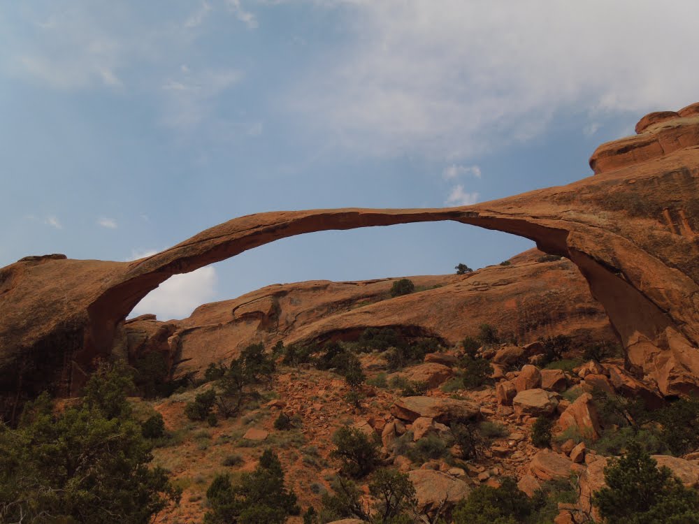
The next morning we headed up to Arches National Park, and drove to the end of the park road to Devil's Garden, to hike out to Landscape Arch, which, at 290 feet may well be the longest in the world:


The trail along the way passed through typically gorgeous Utah scenery...


...and among flowering cacti:


The morning of our last day we drove up to Dead Horse Ranch State Park, 2000' above the valley floor and the Colorado River which carved it. The view from up there is spectacular:


We went there to ride the excellent mountain bike trail that sweeps through the scrub on the mesa-top. This is where Nancy rode last year, and was the inspiration for her getting her own proper mountain bike. Here she is ripping up the trail:


And here I am climbing one of the short, steep hills on the trail:


I continued on to do a longer loop than Nancy was up for, and it brought me to an overlook on a cliff with a sheer dropoff. I couldn't resist the photo opportunity, which I wouldn't have been able to do had Nancy been there!:


Our last evening we joined a "Jeep" Tour, which was actually a Hummer tour, with High Point tours. We piled into a Humvee that had been modified to seat 10, including the driver, Josh. We drove up to the salt flats, and pulled onto the Hell's Revenge 4X4 trail. This challenging jeep trail has a natural "filter" at its start - a 90 degree turn up onto a ribbon of sandstone with sheer dropoffs on both sides, requiring a serious four-wheel-drive vehicle with high ground clearance and very short overhangs. It filters out the wanna-be's, allowing only serious, trail-rated vehicles to pass. Here we are descending this same feature:


On our tour we climbed and descended slickrock formations so steep that they seemed impossible for a wheeled vehicle to navigate. The Humvee's impressive off-road abilities were truly demonstrated. It's ability to approach and climb up nearly vertical walls of rock were indeed awesome.


And not everyone who attempts this extreme driving makes it out. Here is a Nissan Pathfinder carcass which serves as a reminder to those unexperienced drivers who think they can take their stock vehicles on Hell's Revenge:


We enjoyed the tour immensely - it's a far cry from what we would have attempted had we rented a stock Jeep Wranger and explored on our own. Good stuff!

So, once again Moab impresses us with the variety and quality of outdoor pursuits available, and with the spectacular sandstone landscapes. Definitely worth a visit or several.